
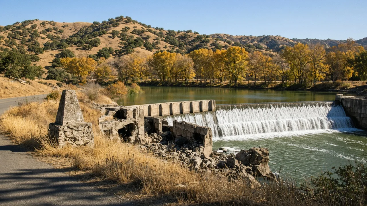
This week's hidden gem near Merced is Merced Falls, a Gold Rush-era ghost town on the north bank of the Merced River, about 4 miles east of Snelling on Merced Falls Road. It is worth the drive for its roadside history marker, the 1901 Merced Falls Dam, and the riverside ruins of a mill that once employed roughly a thousand lumber workers.
What Is Merced Falls?
Merced Falls grew up at a natural crossing of the Merced River in Merced County, where the water ran fast enough to turn a mill wheel. The crossing was first known as California Ranche, then as Belt's Ferry, and the riverbank was already home to a large Native American rancheria when the first settlers arrived. A flour mill was grinding here by 1854, the post office opened on September 4, 1856, and a woolen mill followed in 1867, turning the little settlement into one of the busiest places between Merced and the Sierra. The falls that gave the town its name poured over the riverbed right at the settlement, an easy source of power in a valley with almost none.
The Marker That Tells the Whole Story
There is no entrance gate and no visitor center at Merced Falls, but there is something better: a stone-and-cement monument with a history plaque, erected in 1970 by the E Clampus Vitus historical fraternity and standing beside Merced Falls Road near the dam. The plaque walks you through the town's life in a few lines: the crossing first known as California Ranche, then Belt's Ferry; the large Indian rancheria at the site; the post office that opened in 1856; the flour and woolen mills; the fire that destroyed the town in August 1895; and the Yosemite Lumber Company, which ran a large mill here from 1912 until 1943. It is a full history lesson, free, at the side of a quiet farm road, which is exactly the kind of secret spot near Merced this series is for.
The Mill That Built a River Town
For three decades the site was an industrial powerhouse. The Yosemite Lumber Company's big mill employed roughly a thousand workers at its peak, cutting timber hauled down from the Sierra and served by the Yosemite Valley Railroad, and the town around it supported the crews, the railroad, and the river trade. The concrete foundations and rubble of those operations still stand along the bank behind fencing, visible from the road. Years before the lumber mill arrived, in August 1895, a fire had already destroyed the original town, and like many foothill settlements Merced Falls never quite rebuilt its old self. The mill kept the name working until 1943, and then the town slipped quietly off the map.
A Dam From 1901 Still Spans the River
The reason to stop and linger is the river itself. The 1901 Merced Falls Dam, about 43 feet high and 1,679 feet long, still holds back the Merced a short walk's view from the marker. The falls that named the town are upstream now: the original rapids sit at today's McSwain Dam, and the Lake McSwain and Lake McClure recreation areas begin a few miles up Merced Falls Road, the same water calendar my Lake & Water Activities guide tracks each week. Between the two dams the river runs through a quiet corridor of cottonwoods and golden grassland, and on a clear fall afternoon the water, the ruins, and the foothills make a scene that belongs on a postcard nobody sends.
Why It Stays Off the Tourist Radar
Merced Falls has no highway signage, no parking lot, no gift shop, and no reason for a tour bus to stop. The townsite is mostly private land with occupied homes, so there is no walk-through museum and no rope line, just a public road, a marker, and a dam you can admire from the roadside while respecting the fences. That is the appeal: it is a real ghost town that asks nothing of you except curiosity. Most travelers on the way to Yosemite take Highway 140 or Highway 99 and never turn down Merced Falls Road, and my feature on Snelling explains why the county's first settlements clustered here in the first place: the river, and the road that followed it.
Hidden Gems Near Merced: A River of Stories
Merced Falls is the newest stop on a loop of river history that starts in Merced. About 4 miles west, Snelling, Merced County's first county seat, keeps its restored 1857 courthouse museum. Farther up Merced Falls Road, the McSwain area opens the two reservoirs that anchor the county's recreation calendar, and in the foothills the Gold Rush towns of Hornitos and Coulterville wait on Highways 140 and 49. Every one of these is a hidden gem near Merced, and Merced Falls is the easiest one to reach on the way to the others.
Practical Visit Notes
The marker, dam views, and ruins are free and publicly accessible year-round from Merced Falls Road; the townsite is private, so stay on the road and the shoulder. From Merced, take Highway 59 north about 17 miles to Snelling, turn right onto Merced Falls Road, and continue about 4 miles to the site, roughly 30 to 40 minutes and 20 to 23 miles total. There are no services at Merced Falls, so bring water and snacks. Fall and spring are the best seasons, with mild days and low water; after winter rain the river runs fast and the spill at the dam is worth seeing. The Merced County Events history of Merced Falls and the Historical Marker Database entry include the full plaque text and photographs.
Why Hidden Gems Matter to Home Sellers
Monica shares these picks because a community's character shows up in the places people love, and buyers feel it too. A river town like Merced Falls gives the county's rural corners a sense of history and place that no brochure can fake. For sellers, the same local knowledge shows up in her approach to Merced County real estate, where market insight and community character go hand in hand.
Frequently Asked Questions
What are some hidden gems near Merced?
Merced Falls is one of the best: a Gold Rush-era ghost town on the Merced River, about 4 miles east of Snelling, with a roadside history marker and the 1901 hydroelectric dam. For every pick in the series, browse the Hidden Gems Archive.
Where is Merced Falls, California?
Merced Falls is an unincorporated ghost town in Merced County on the north bank of the Merced River, about 4 miles east of Snelling on Merced Falls Road and roughly 20 to 23 miles north of downtown Merced.
Is Merced Falls open to the public?
The townsite is mostly private land, but the roadside history marker and the views of the 1901 Merced Falls Dam and the old mill ruins are publicly accessible from Merced Falls Road year-round. Visitors should stay on the road and respect private-property boundaries.
What happened to Merced Falls?
The settlement began at a river crossing known first as California Ranche, then as Belt's Ferry. The post office opened in 1856, a fire destroyed the town in August 1895, and the Yosemite Lumber Company mill kept the name on the map from 1912 until 1943, when the town faded.
What is the Merced Falls Dam?
The Merced Falls Dam is a 1901 hydroelectric dam on the Merced River, about 43 feet high and 1,679 feet long. The original falls that named the town are upstream at today's McSwain Dam.
What else is worth seeing near Merced Falls?
Snelling's restored 1857 courthouse museum is about 4 miles west, the Lake McSwain and Lake McClure recreation areas begin a few miles up the road, and the Gold Rush towns of Hornitos and Coulterville are within an easy drive.
Why Merced Falls is a hidden gem near Merced
Merced Falls stands out as a hidden gem near Merced because it preserves a full chapter of river history in a place most drivers pass right by. It is a genuine Merced County ghost town: the post office opened in 1856, a fire destroyed the town in 1895, and the Yosemite Lumber Company ran a large mill here from 1912 to 1943. Today the roadside history marker, the 1901 Merced Falls Dam, and the concrete ruins along the river tell the story for free, about 20 miles north of Merced and 4 miles east of Snelling. For anyone searching for hidden gems in Merced or secret spots near Merced, or a quiet historic day trip from the Central Valley, Merced Falls is the pick.
Find your own favorite spot, Merced.
And when you are ready to talk about your home, Monica is here. She offers a free, no-obligation consultation for sellers across Merced County and the Central Valley.
Talk to Monica
The Seller's Agent. Monica combines 27 years of real estate experience with deep Merced County market knowledge to deliver results for home sellers across the Central Valley.
Add Monica Franks as a Preferred Source on Google to see more of my content in AI Mode and AI Overviews.
Add as Preferred Source